Central America comprises what Geographic Landform?
Step 1: Go to the ArcGIS Online map, An Eye on Central America, and explore the map.
Step 2: With the Details button underlined, click the button, Show Contents.
There are several definitions of which countries compose Central America. This inquiry considers the seven countries south of Mexico.
An isthmus is a narrow strip of land with sea on either side, forming a link between two larger areas of land.
- Central American countries are considered an isthmus because it connects the large landmass of Mexico, South America, and the Caribbean Sea. (T/F)
What are the physical characteristics of Central America?
Step 3: Click the button, Bookmarks. Select Central America.
- Which countries make up Central America?
Step 4: Check the box left of the layer name, Holocene Volcanoes?
- What is the elevation or terrain in these countries?
Step 5: Turn off the World Oceans layer. Turn on the Rivers layer.
Step 6: Select the bookmark, Rivers.
Step 7: Drag the map to view all the Central American countries.
- Rivers are plentiful and appear to start in the higher elevations, and run west toward the Pacific Ocean or east toward the Caribbean Sea. (T/F)
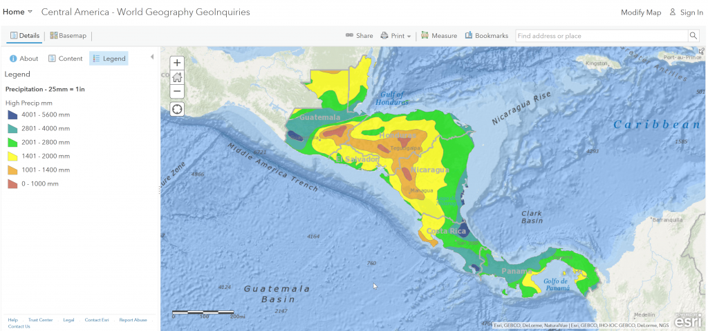
What is the pattern of yearly precipitation across Central American countries?
Step 8: Turn off the layers, Rivers.
Step 9: Select the bookmark, Central America.
Step 10: Turn on the Precipitation layer and click the Show Legend button.
- Describe the precipitation patterns compared to the mountains.
In the United States, Nevada ranks as the driest state, with an average annual precipitation of 9.5 inches, and Hawaii is the wettest, at 70.3 inches.
- The areas with the least amount of rain in Central America receive over four times the amount of the driest state of Nevada, and areas with the most rainfall in Central America receive over three and half times as much rain as Hawaii. (T/F)
Where are the populous areas of Central America?
Step 11: Turn off the Precipitation and Volcanoes layers, and turn on the Population Density layer and view its legend.
- Though urban areas are in coastal plains, the higher-density extreme urban areas are in the higher and drier mountainous areas. (T/F)
What effect might a hurricane have on Central America?
Step 12: Turn on the Hurricane Mitch and Hurricane Mitch Satellite layers. Click the icon and read the information provided.
- In four days, Honduras received almost as much rain as Hawaii does annually. The amount of rain in a few days would cause severe flooding and loss of life. (T/F)
